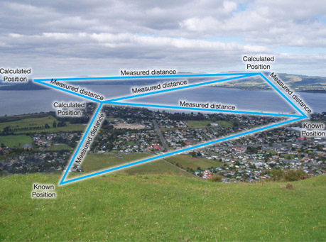
Triangulation Survey is generally carried out to establish the precise control points network specifically in the hilly areas as measurement of angles in hilly terrains becomes easier than measuring the very long distances. In Triangulation Surveys a network of triangles is formed in the area of interest.
One line which is called the base line is measured along with angles and the balance two distances in the triangle is calculated to establish the control points. It is important and ideal to form triangles with base angles of about 45 degrees as in long triangles chances of inaccuracies are higher. The calculated distance of each arm of the triangle is used and one of the known side of another triangle for calculating the distances to another points to form another triangle. By repeating these steps a chain of triangles is formed and the angles / distances are used to calculate the precise position of all the node points / control points of the triangulation network. At ARK Services Pvt. Ltd. we use highly sophisticated equipment to establish the triangulation network mainly for Hydro Power or any other hilly terrain survey project or as per the guidelines / instructions of our Client.