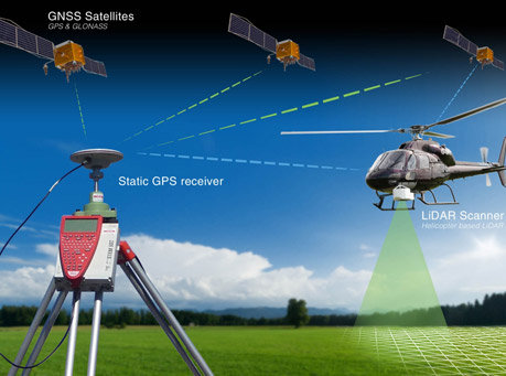
LIDAR (LiDAR or Light Detection And Ranging) Survey uses the laser light for measurement of distances by illuminating the objects of interest. LiDAR Survey is generally carried out to make high resolution maps in the remote and tough terrains where conventional surveying techniques are extremely difficult to adopt. Using LiDAR Survey vast areas can be surveyed in a very less time as compared to conventional surveys with better precisions. The most important applications for Surveying and Civil Engineering are aerial scanning and terrestrial scanning. Because of advancement in the technology LiDAR survey can be used for topographic mapping. Using Terrestrial Scanning 3D models of complex objects such as pipelines, highways, structures, bridges, flyovers etc can be made with much more ease and precision. Using LiDAR survey rural and remote areas can be surveyed in a much easier and quicker manner because each point collected and picked using LiDAR has geo-referenced location and elevation. We at ARK Services Pvt. Ltd. provide high precision LiDAR Surveys for vast applications.