GPS technology has matured into a resource that goes far beyond its original design goals. These days scientists, sportsmen, farmers, soldiers, pilots, surveyors, hikers, delivery drivers, sailors, dispatchers, lumberjacks, and fire-fighters are using GPS in ways that make their work more productive, safer, and sometimes even easier. GPS plays an important role in establishing horizontal and vertical control for every type of topographic survey and GIS mapping.
GPS is capable of determining accurate positional, velocity, and timing information. The GPS provides positional and navigational data to all communities in the form of two positional services. Single GPS receiver (absolute positioning) does not get high-accuracy and instantaneous positioning. The Precise Positioning can obtain high-accuracy, instantaneous positioning if the receiver is capable of accepting the necessary corrections.
There are two types of positioning methods Absolute and differential (relative) positioning methods. Differential Positioning methods provide accurate and timely positional data. The method of choice depends on the accuracy required, the equipment available, and the logistical requirements. The positioning methods are described as follows:
Absolute positioning uses a single GPS receiver and does not require known survey control. Absolute positions can provide instantaneous (real-time) or post processed positions.
Differential positioning uses two or more GPS receivers. One GPS receiver (Base Station) is placed at a known location. The remaining receivers (remote receivers) are used to position points of interest. Differential positioning can be performed in real time or through post processing. If real-time positioning results are required, a communications link that is capable of transmitting digital data must be established at the Base and Mobile locations. This method supports distances up to 100 kilometers between the base and mobile stations. Real-time and post processed differential positioning can provide relative accuracy of 1 centimeter or better.
The accuracy of GPS depends upon the user's equipment and the surveying method used (absolute real-time or differential). The use of GPS receivers has improved the efficiency and productivity of topographic surveyors in conducting surveys and giving positioning control.
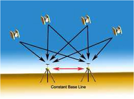
GPS surveying conducted using two or more receivers is called DGPS surveying. The error factors are determined and compensated from the survey (position of mobile station) either by real-time processing or post processing of the data. The type of DGPS survey used is dependent on accuracy requirements of any survey. There are two basic types of DGPS surveys 1) Static Survey and 2) Dynamic Survey.
Static survey uses a stationary set of receivers that collect simultaneous observations at synchronized time over a predetermined time interval and provide the best accuracy to the user.
Dynamic survey uses one stationary receiver, which is called base station and any number of remote or moving receivers. Using this method user can collect data during movement. In the real-time mode, the mobile receiver can provide very accurate positions almost instantaneously in the field itself.
We at ARK Services Pvt. Ltd. are fully equipped with Real time and Post Processing DGPS hardware & software and mapping, plotting and survey-application software. By deploying high accuracy DGPS and providing horizontal and vertical positioning control to all our Topographic Survey projects, we ensure the efficient and accurate results to our clients which exceeds their expectation
Applications: