Our Earth is oblate spheroid in shape which makes it slightly oblong in appearance. It flattens at poles and bulges at equator. Given the oblate spheroid shape of our earth, any linear survey carried out covering a larger piece of land would lead to inaccuracies. For carrying out the surveys covering relatively larger piece of land would require higer degree of accuracy in linear and angular observations. Geodetic Survey is the branch of survey in which the curvature of the earth is considered the important parameter and higher degree of precision is achieved. While surveying larger areas, a linear line connecting any two points on earth is never considered a straight line rather it is considered an Arc. Hence the distances shown on the two dimensional topographic maps is not same as the linear distance between the points. The necessary corrections for the curvature or arc is applied to calculate the actual distance and after necessary corrections the maps are prepared with utmost accuracy required for such surveys. Geodetic Surveys makes use of spherical trigonometry for making the desired measurements and calculations.
Using Geodetic surveys major control points spread over the macro area of interest are provided which are further used to carry out the plane surveys in micro areas. Whole to part principle of surveying is used in these types of surveys rather than part to whole.
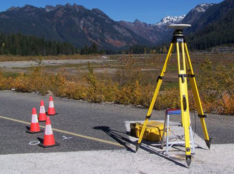
Highly sophisticated instruments such as Differential Global Positioning Systems are used to carry out such Geodetic Surveys. ARK Services Pvt. Ltd. is having inhouse DGPS Systems and experts having decades of experience of carrying out Godetic Surveys with highest precision.
Applications: